
We showcase how to upload tabular and spatial data to R2.
Tabular data
As an example consider the geographic attributes file for the 2021
census. StatCan has disabled programmatic download, so the file has to
be downloaded
manually and unzipped into download_path, so that
2021_92-151_X.csv is directly in it.
path <- file.path(params$download_path, "2021_92-151_X.csv")The file has close to half a million rows, one per dissemination
block, and takes 300 MB as CSV. Rather than reading it into R, we let
DuckDB read it lazily, data_to_parquet() then writes lazy
DuckDB tables with a single DuckDB COPY straight from the
CSV to parquet, and uploads the parquet file, without the data ever
being read into an R data frame. The upload itself sends each file in a
single request and reads it into memory for that, so files have to fit
into memory and stay below R2’s 5 GB limit for single requests, larger
data gets split with partition_by (see the Metadata and manifests article for what a
partitioned dataset looks like).
Trial and error determined that the CSV is Windows-1252 encoded,
which DuckDB reads via its encodings extension. We read all
columns as text, otherwise DuckDB would turn codes like
SACCODE "001" into numbers, and convert the
numeric columns explicitly instead. The column names are bilingual, like
DBUID_IDIDU, we keep the English part.
csv_con <- DBI::dbConnect(duckdb::duckdb())
DBI::dbExecute(csv_con, "INSTALL encodings") |> invisible()

geo_attributes <- tbl(csv_con, sql(paste0(
  "FROM read_csv(", DBI::dbQuoteString(csv_con, path),
  ", encoding = 'cp1252', all_varchar = true)"))) |>
  rename_with(\(name) sub("_.*", "", name)) |>
  mutate(across(c(DBPOP2021, DBTDWELL2021, DBURDWELL2021), as.integer),
         across(c(DARPLAMX, DARPLAMY, DARPLAT, DARPLONG, DBAREA2021), as.numeric))

geo_attributes
#> # A query:  ?? x 63
#> # Database: DuckDB 1.5.6 [jens@Darwin 27.0.0:R 4.6.1/:memory:]
#>    PRUID PRDGUID     PRNAME PRENAME PRFNAME PREABBR PRFABBR CDUID CDDGUID CDNAME
#>    <chr> <chr>       <chr>  <chr>   <chr>   <chr>   <chr>   <chr> <chr>   <chr>
#>  1 10    2021A000210 Newfo… Newfou… Terre-… N.L.    T.-N.-… 1001  2021A0… Divis…
#>  2 10    2021A000210 Newfo… Newfou… Terre-… N.L.    T.-N.-… 1001  2021A0… Divis…
#>  3 10    2021A000210 Newfo… Newfou… Terre-… N.L.    T.-N.-… 1001  2021A0… Divis…
#>  4 10    2021A000210 Newfo… Newfou… Terre-… N.L.    T.-N.-… 1001  2021A0… Divis…
#>  5 10    2021A000210 Newfo… Newfou… Terre-… N.L.    T.-N.-… 1001  2021A0… Divis…
#>  6 10    2021A000210 Newfo… Newfou… Terre-… N.L.    T.-N.-… 1001  2021A0… Divis…
#>  7 10    2021A000210 Newfo… Newfou… Terre-… N.L.    T.-N.-… 1001  2021A0… Divis…
#>  8 10    2021A000210 Newfo… Newfou… Terre-… N.L.    T.-N.-… 1001  2021A0… Divis…
#>  9 10    2021A000210 Newfo… Newfou… Terre-… N.L.    T.-N.-… 1001  2021A0… Divis…
#> 10 10    2021A000210 Newfo… Newfou… Terre-… N.L.    T.-N.-… 1001  2021A0… Divis…
#> # ℹ more rows
#> # ℹ 53 more variables: CDTYPE <chr>, FEDUID <chr>, FEDDGUID <chr>,
#> #   FEDNAME <chr>, CSDUID <chr>, CSDDGUID <chr>, CSDNAME <chr>, CSDTYPE <chr>,
#> #   DPLUID <chr>, DPLDGUID <chr>, DPLNAME <chr>, DPLTYPE <chr>, ERUID <chr>,
#> #   ERDGUID <chr>, ERNAME <chr>, CCSUID <chr>, CCSDGUID <chr>, CCSNAME <chr>,
#> #   SACTYPE <chr>, SACCODE <chr>, CMAPUID <chr>, CMAPDGUID <chr>, CMAUID <chr>,
#> #   CMADGUID <chr>, CMANAME <chr>, CMATYPE <chr>, CTUID <chr>, CTDGUID <chr>, …
Sorting by the dissemination block id keeps the blocks of each province, census division and subdivision together in the same row groups, so queries filtering on these only download the row groups they need.
We also encode basic metadata on data provenance and licence to give
clarity what the data is and where it comes from, and declare the
primary key, the dissemination block id that identifies each row.
data_to_parquet() checks that it does before writing.
metadata <- list(
  "title"="2021 Census – Geographic Attribute File",
  "source_url"="https://www12.statcan.gc.ca/census-recensement/2021/geo/aip-pia/attribute-attribs/index2021-eng.cfm?year=2021",
  "reference_guide"="https://www150.statcan.gc.ca/n1/en/catalogue/92-151-G2021001",
  "licence"="Statistics Canada Open Licence",
  "licence_url"="https://www.statcan.gc.ca/en/terms-conditions/open-licence",
  "attribution"="Statistics Canada Product 2021_92-151_X",
  "primary_key"="DBUID"
)
data_to_parquet(geo_attributes, "r2://test/census/2021/2021_92-151_X.parquet",
                sort_by = "DBUID", metadata = metadata)
#> Uploading 10.2 MB in 1 parquet file to r2://test/census/2021/2021_92-151_X.parquet.

DBI::dbDisconnect(csv_con, shutdown = TRUE)
Reading it back, e.g. the population and dwellings by census subdivision in the Montréal CMA:
parquet_tbl("r2://test/census/2021/2021_92-151_X.parquet") |>
  filter(CMAUID == "462") |>
  summarise(Population = sum(DBPOP2021, na.rm = TRUE),
            Dwellings = sum(DBTDWELL2021, na.rm = TRUE),
            .by = CSDNAME) |>
  arrange(desc(Population)) |>
  collect()
#> # A tibble: 93 × 3
#>    CSDNAME                  Population Dwellings
#>    <chr>                         <dbl>     <dbl>
#>  1 Montréal                    1762949    878542
#>  2 Laval                        438366    176115
#>  3 Longueuil                    254483    117006
#>  4 Terrebonne                   119944     46056
#>  5 Saint-Jean-sur-Richelieu      97873     44255
#>  6 Brossard                      91525     37275
#>  7 Repentigny                    86100     34710
#>  8 Saint-Jérôme                  80213     38776
#>  9 Mirabel                       61108     25514
#> 10 Blainville                    59819     22859
#> # ℹ 83 more rows
Spatial data
For this we consider hosting the StatCan metro area (CMA) level
geographies from the 2021 census. StatCan has disabled programmatic
download, so the geodatabase has to be downloaded
manually and unzipped so that it ends up at
lcma000b21f_e/lcma000b21f_e.gdb within
download_path.
We then read the data and cast it to MULTIPOLYGON. Some StatCan geography files contain MULTISURFACE geometries, which have to be converted before writing parquet files, for this file the cast does not change anything.
cma_geos <- sf::st_read(file.path(params$download_path,"lcma000b21f_e/lcma000b21f_e.gdb"),
                        quiet = TRUE) |>
  sf::st_cast("MULTIPOLYGON")
We then write this to a parquet file on R2, with the first path
component being the bucket, which has to exist already (see
create_r2_bucket() and the Setting up R2 article for the credentials
needed).
We again create a basic metadata template. CMAs that cross a provincial boundary, like Campbellton in New Brunswick and Quebec, have one row for each province, so the CMA id alone does not identify rows, the primary key is the CMA id together with the province id.
metadata <- list(
  "title"="2021 Census – Boundary files - Census metropolitan areas and census agglomerations",
  "source_url"="https://www12.statcan.gc.ca/census-recensement/alternative_alternatif.cfm?l=eng&dispext=zip&teng=lcma000b21g_e.zip&k=%20%20%20%2011472&loc=//www12.statcan.gc.ca/census-recensement/2021/geo/sip-pis/boundary-limites/files-fichiers/lcma000b21g_e.zip",
  "reference_guide"="https://www12.statcan.gc.ca/census-recensement/2021/geo/ref/guide/index2021-eng.cfm?year=21",
  "licence"="Statistics Canada Open Licence",
  "licence_url"="https://www.statcan.gc.ca/en/terms-conditions/open-licence",
  "attribution"="Statistics Canada Product lcma000b21f_e",
  "primary_key"=c("CMAUID", "PRUID")
)
Under the hood data_to_parquet() renames the geometry
column to geometry, repairs invalid geometries, orders the
rows by the sort_by columns, if any, and further along a
Hilbert curve, and uploads the resulting GeoParquet file.
data_to_parquet(cma_geos, "r2://test/census/2021/lcma000b21f_e.parquet",
                sort_by = "CMAUID", metadata = metadata )
#> Renaming geometry column SHAPE to the GeoParquet standard name geometry.
#> Repairing 2 invalid geometries via sf::st_make_valid.
#> Uploading 12.9 MB in 1 parquet file to r2://test/census/2021/lcma000b21f_e.parquet.
Repairing geometries changes the data, so
data_to_parquet() records it in the metadata:
processing says how many geometries were repaired and with
which version of the geometry library, and geometry_repairs
lists the repaired rows by their primary key. Without a declared primary
key it uses the first column or a column whose name ends in
ID if one of them identifies the rows, and records just the
number with a warning otherwise.
parquet_metadata("r2://test/census/2021/lcma000b21f_e.parquet")
#> <parquet metadata: 9 entries>
#> title             2021 Census – Boundary files - Census metropolitan areas and …
#> source_url        https://www12.statcan.gc.ca/census-recensement/alternative_al…
#> reference_guide   https://www12.statcan.gc.ca/census-recensement/2021/geo/ref/g…
#> licence           Statistics Canada Open Licence
#> licence_url       https://www.statcan.gc.ca/en/terms-conditions/open-licence
#> attribution       Statistics Canada Product lcma000b21f_e
#> primary_key       CMAUID, PRUID
#> geometry_repairs  {"columns":["CMAUID","PRUID"],"rows":[["571","35"],["705","47…
#> processing        Repaired 2 of 156 geometries that were invalid, via sf::st_ma…
The uploaded file can be queried lazily right away, here we read the Montréal CMA.
con <- parquet_tbl("r2://test/census/2021/lcma000b21f_e.parquet")

data <- con |>
  filter(CMAUID == "462") |>
  collect_parquet()
#> Collecting all 9 columns of r2://test/census/2021/lcma000b21f_e.parquet. Parquet is stored by column and only the selected columns get downloaded, so select the ones you need: add
#>   select(CMAUID, CMAPUID, DGUID, DGUIDP, CMANAME, CMATYPE, LANDAREA, PRUID, geometry)
#> to the query and remove the columns you don't need. This message is shown once per session.

ggplot(data) +
  geom_sf() +
  labs(title = "Montréal CMA boundary",
caption=parquet_sources_attribution(data)) 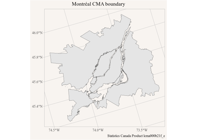
plot of chunk montreal
The metadata is accessible from the lazy table con as
well as from the collected data, and is used here for the
caption.
Other files
Rebuilding a dataset locally and uploading the directory again with
upload_parquet() leaves files on R2 that the rebuild no
longer produces, a partition or a per-region file that was dropped, and
the manifest keeps listing them.
upload_parquet(remove_stale = TRUE) removes the parquet
files below the destination that are not in the local directory first,
so that the destination mirrors the directory. It is off by default
since it deletes files.
Datasets often come with files that are not parquet, like a JSON
index that a web client reads first, or a README.
upload_parquet() uploads single files of any type with the
content type for their extension, application/json for a
.json file say, so browsers and other clients handle them
correctly, and purges them from the Cloudflare cache like it does for
parquet files. remove_parquet() removes them when given
their path, while removing a directory only touches its parquet files
and manifests.
Manifests
Directory uploads put a _manifest.json next to the data,
which lists the parquet files below the directory with their size, etag
and modification time, and the metadata from their footers: entries that
all files share, like the columns descriptions of a
partitioned dataset, at the dataset level and the rest with the file.
The package uses it to cache directories from public URLs, where listing
is not possible, and clients that are not R can read what a dataset
holds from it without opening the files. parquet_metadata()
reads it for paths on R2 and at URLs, one request for a whole dataset
instead of a footer read per file,
parquet_metadata(from_files = TRUE) reads the footers
themselves. The format is documented in ?write_manifest,
which adds manifests to directories that were uploaded by other means;
it reads the metadata from the footers on R2, one request per file. The
Metadata and manifests article walks through
the pieces.
Cleanup
To leave things as we found them initially we remove the files we uploaded here from the test bucket.
remove_parquet(c("r2://test/census/2021/2021_92-151_X.parquet",
                 "r2://test/census/2021/lcma000b21f_e.parquet"))
#> Removed 2 files from R2 bucket test.